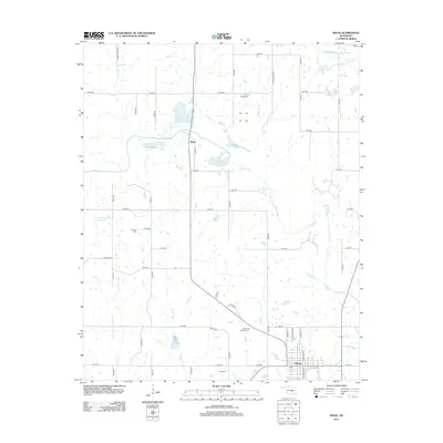
2012 Map of Maud
USGS Topo · Published 2012About this map
The town of Maud sits at the intersection of local routes in this portion of Oklahoma, where the landscape is defined by the winding course of the Little River. North of the main settlement, the community of Harjo is situated along a central corridor, surrounded by a network of rural roads that connect family-interest sites. Researchers will find several burial grounds across the area, including Union Cemeteries, Fairview Cem, and Dripping Springs Cem, reflecting the region's long-established local heritage. The terrain is marked by numerous water bodies, from the J E McSpadden Reservoir to tributaries like Marcum Cr and Brier Cr. The detailed road network, including uniquely named thoroughfares such as Econtuschka Rd, provides a clear view of the rural property boundaries and community layout at the start of the 2010s.
Find a feature on this map
45 named features on this map. Tap any name to fly to it.
Don’t see what you’re looking for? This feature index may not catch every label — zoom into the map to look around manually.
Map Details
Editions of this 2012 Maud Map
This is the sole edition of this map. No revisions or reprints were ever made.
Other maps of this area

1896 · Seminole and Prague
USGS Topo · 1:125,000

1907 · Maud
USGS Topo · 1:62,500

1908 · Maud
USGS Topo · 1:62,500

1909 · Shawnee
USGS Topo · 1:62,500

1954 · Oklahoma City
USGS Topo · 1:250,000

1957 · Oklahoma City
USGS Topo · 1:250,000
1958 · Pearson
USGS Topo · 1:24,000

1963 · Oklahoma City
USGS Topo · 1:250,000

1967 · Prague SW
USGS Topo · 1:24,000
1967 · Shawnee
USGS Topo · 1:24,000