
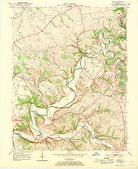
1953 Map of Maud
USGS Topo · Published 1954About this map
The Beech Fork and Chaplin River wind through the borderlands of Nelson and Washington Counties, defining a landscape of deep river bends and rural crossroads. In the early 1950s, the region was anchored by small agrarian hubs such as Maud and Mooresville, where local education centered on the Maud Consolidated Sch. The southern portion of the map is dominated by the Cartwright Creek valley, leading toward the historic settlement of Fredericktown. This area preserves a dense record of family history through its numerous small burial grounds, including the Wilkinson Cem, Dodson Cem, and Beam Cem. Spiritual life is marked by several country churches like Walkers Chapel and New Hope Ch, while the Louisville and Nashville tracks provide a vital transport link through the northern hills near Cooney Neck.
Find a feature on this map
46 named features on this map. Tap any name to fly to it.
Don’t see what you’re looking for? This feature index may not catch every label — zoom into the map to look around manually.
Map Details
Editions of this 1953 Maud Map
2 editions found
Other maps of this area

1952 · Chaplin
USGS Topo · 1:24,000

1953 · Loretto
USGS Topo · 1:24,000

1953 · Brush Grove
USGS Topo · 1:24,000

1953 · Saint Catharine
USGS Topo · 1:24,000

1953 · Bardstown
USGS Topo · 1:24,000

1953 · Springfield
USGS Topo · 1:24,000

1953 · Bloomfield
USGS Topo · 1:24,000

1953 · Fairfield
USGS Topo · 1:24,000

1957 · Winchester
USGS Topo · 1:250,000

1960 · Winchester
USGS Topo · 1:250,000