
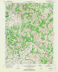
1953 Map of Brush Grove
USGS Topo · Published 1954About this map
The Chaplin River and Beech Fork carve deep, winding paths through this section of Washington and Nelson counties, creating a landscape defined by narrow ridges and sharp river bends. In the south, Lincoln Homestead State Park and the nearby Lincoln Park Sch mark a region significant to Kentucky heritage, situated along Lincoln Run. The settlement pattern is scattered among the uplands, with small crossroads and communities like Willisburg, Brush Grove, and Polin serving as local anchors.
Find a feature on this map
29 named features on this map. Tap any name to fly to it.
Don’t see what you’re looking for? This feature index may not catch every label — zoom into the map to look around manually.
Map Details
Editions of this 1953 Brush Grove Map
2 editions found
Other maps of this area

1952 · Ashbrook
USGS Topo · 1:24,000

1952 · Chaplin
USGS Topo · 1:24,000

1953 · Mackville
USGS Topo · 1:24,000

1953 · Maud
USGS Topo · 1:24,000

1953 · Saint Catharine
USGS Topo · 1:24,000

1953 · Cardwell
USGS Topo · 1:24,000

1953 · Springfield
USGS Topo · 1:24,000

1953 · Bloomfield
USGS Topo · 1:24,000

1957 · Winchester
USGS Topo · 1:250,000

1960 · Winchester
USGS Topo · 1:250,000