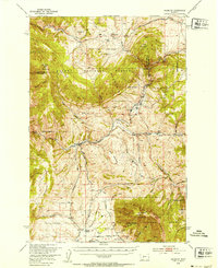
1949 Map of Maudlow
USGS Topo · Published 1954About this map
The settlement of Maudlow sits at the junction of Sixteenmile Creek and the Chicago Milwaukee St Paul And Pacific railroad, serving as a focal point for the ranching operations spread throughout this portion of Gallatin and Broadwater Counties. In the years following the war, this landscape remained defined by family-named holdings such as the Mitchell Ranch, Koenig Ranch, and Morgan Ranch. The distribution of rural education is evident through several local institutions, including Francis School, Josephine School, and Durham School, which anchored the small communities of the foothills.
Find a feature on this map
52 named features on this map. Tap any name to fly to it.
Don’t see what you’re looking for? This feature index may not catch every label — zoom into the map to look around manually.
Map Details
Editions of this 1949 Maudlow Map
4 editions found

Other maps of this area

1886 · Fort Logan
USGS Topo · 1:250,000

1886 · Little Belt Mts.
USGS Topo · 1:250,000

1888 · Three Forks
USGS Topo · 1:250,000

1891 · Livingston
USGS Topo · 1:250,000

1893 · Livingston
USGS Topo · 1:250,000

1894 · Three Forks
USGS Topo · 1:250,000

1894 · Little Belt Mts.
USGS Topo · 1:250,000

1895 · Three Forks
USGS Topo · 1:250,000

1897 · Little Belt Mts.
USGS Topo · 1:250,000

1898 · Little Belt Mts.
USGS Topo · 1:250,000