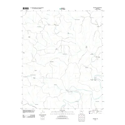
2011 Map of Maumee
USGS Topo · Published 2011About this map
The Buffalo River carves through this northern Arkansas landscape, defining the southeastern corner of the quadrangle near Maumee Crossing. This 2011 survey captures a region of deeply dissected terrain, where numerous family-named hollows like Harris Hollow and Granny Price Hollow illustrate a history of local settlement and land use. Small communities such as Maumee, Freck, and Tomahawk serve as focal points for the rural road network, which winds through the many drainages. Genealogists will find several burial grounds documented, including Burns Cemetery, Tomahawk Cemetery, and Caney Cemetery. The presence of Copper Mine Hollow hints at earlier mineral prospecting, while natural features like Lay Falls and Elm Cave Hollow highlight the specific karst and water-driven topography of the Ozark region. The map provides a detailed view of the complex hydrology of Tomahawk Creek and Water Creek as they feed into the larger river system.
Find a feature on this map
86 named features on this map. Tap any name to fly to it.
Don’t see what you’re looking for? This feature index may not catch every label — zoom into the map to look around manually.
Map Details
Editions of this 2011 Maumee Map
This is the sole edition of this map. No revisions or reprints were ever made.
Other maps of this area

1892 · Marshall
USGS Topo · 1:125,000

1893 · Yellville
USGS Topo · 1:125,000

1894 · Marshall
USGS Topo · 1:125,000

1901 · Marshall
USGS Topo · 1:125,000

1903 · Yellville
USGS Topo · 1:125,000

1905 · Yellville
USGS Topo · 1:125,000

1929 · Yellville
USGS Topo · 1:125,000

1939 · Snowball
USGS Topo · 1:62,500

1941 · Snowball
USGS Topo · 1:62,500

1942 · Snowball
USGS Topo · 1:62,500