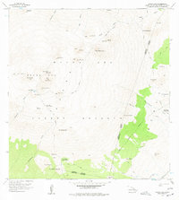
1956 Map of Mauna Kea
USGS Topo · Published 1977About this map
Puu Wekiu and the high cinder cones of Mauna Kea Forest Reserve dominate this mid-century topographic survey. The landscape is defined by the unique volcanic geology of the summit, including the high-altitude Lake Waiau and the culturally significant Keanakakoi (Ancient Quarry). These features reflect a legacy of traditional resource gathering at extreme elevations, long before the proliferation of modern observatories.
Find a feature on this map
49 named features on this map. Tap any name to fly to it.
Don’t see what you’re looking for? This feature index may not catch every label — zoom into the map to look around manually.
Map Details
Editions of this 1956 Mauna Kea Map
3 editions found

Other maps of this area

1927 · Kaohe
USGS Topo · 1:62,500

1930 · Humuula
USGS Topo · 1:62,500

1930 · Kaohe
USGS Topo · 1:62,500

1954 · Hawaii North
USGS Topo · 1:250,000

1956 · Puu Oo
USGS Topo · 1:24,000

1956 · Pua Akala
USGS Topo · 1:24,000

1956 · Puu Koli
USGS Topo · 1:24,000

1956 · Keanakolu
USGS Topo · 1:24,000

1956 · Upper Piihonua
USGS Topo · 1:24,000

1956 · Makahalau
USGS Topo · 1:24,000