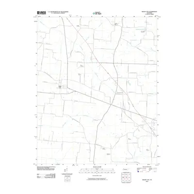
2010 Map of Maury City
USGS Topo · Published 2010About this map
Maury City serves as the primary hub of this western Tennessee landscape, where a dense network of country roads connects family farms and local landmarks. The region is defined by its numerous small burial grounds, including Bridget Cemetery, Nunn Cemetery, and Pond Creek Cemetery, which offer valuable locations for genealogical research. To the northeast, the Crockett Mills Post Office stands near the headwaters of Tucker Creek, marking another point of community gathering. The terrain is crisscrossed by several waterways such as Epperson Creek and Buck Creek, which drain into the larger Pond Creek system. Cultural and family history is preserved in the naming of local features like Joe Cottons Lake and its associated Joe Cottons Lake Dam. The road system, with names like Frog Jump Rd and Johnny Powell Rd, reflects a deeply rooted rural infrastructure that has persisted into the modern era.
Find a feature on this map
74 named features on this map. Tap any name to fly to it.
Don’t see what you’re looking for? This feature index may not catch every label — zoom into the map to look around manually.
Map Details
Editions of this 2010 Maury City Map
This is the sole edition of this map. No revisions or reprints were ever made.
Other maps of this area

1939 · Halls
USGS Topo · 1:62,500

1952 · Bonicord
USGS Topo · 1:24,000

1952 · Chestnut Bluff
USGS Topo · 1:24,000

1956 · Blytheville
USGS Topo · 1:250,000

1959 · Blytheville
USGS Topo · 1:250,000

1959 · Bells
USGS Topo · 1:24,000

1961 · Jones
USGS Topo · 1:24,000

1961 · Halls
USGS Topo · 1:62,500
1964 · Tibbs
USGS Topo · 1:24,000
1964 · Maury City
USGS Topo · 1:24,000