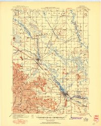
1921 Map of Mauston
USGS Topo · Published 1950About this map
Mauston and New Lisbon serve as the primary hubs of Juneau County in this early twentieth-century survey, situated along the winding course of the Lemonweir River. The landscape is a mix of river bottomlands and dramatic bluff formations like Point Bluff and Steamboat Rock, providing a detailed record of rural settlement before modern highway expansion. A dense network of one-room schoolhouses, including Welsh Prairie School, American Elm School, and Knickerbocker School, highlights the decentralized nature of education at the time.
Find a feature on this map
69 named features on this map. Tap any name to fly to it.
Don’t see what you’re looking for? This feature index may not catch every label — zoom into the map to look around manually.
Map Details
Editions of this 1921 Mauston Map
2 editions found
Other maps of this area

1901 · The Dells
USGS Topo · 1:62,500

1919 · Kendall
USGS Topo · 1:62,500

1921 · Mauston
USGS Topo · 1:62,500

1921 · Kendall
USGS Topo · 1:62,500

1927 · Hillsboro
USGS Topo · 1:62,500

1953 · Eau Claire
USGS Topo · 1:250,000

1955 · Green Bay
USGS Topo · 1:250,000

1956 · Reedsburg
USGS Topo · 1:62,500

1957 · Wisconsin Dells
USGS Topo · 1:62,500

1957 · Madison
USGS Topo · 1:250,000