
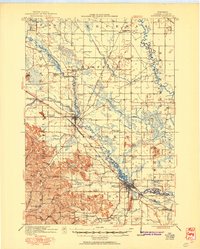
1921 Map of Mauston
USGS Topo · Published 1921About this map
The Lemonweir River and its many tributaries, including Duck Creek and Sevenmile Creek, dominate this central Wisconsin landscape during the early 1920s. The region is defined by a dense network of country schools, such as Welsh Prairie School, Baker School, and American Elm School, indicating a well-established and thriving rural farming population. The map captures the significant rail presence of the Chicago Milwaukee and St Paul and Chicago and N W railroads, which converge near New Lisbon, facilitating the movement of goods from local hubs like Orange Mill. To the south, the topography shifts from the river plains to the more varied terrain of Ryder Ridge and Mullin Ridge, where smaller valleys like Johnson Valley provided secluded pockets for settlement. Large public and institutional footprints, including the Wisconsin Military Reservation and the Juneau County Farm, are clearly delineated.
Find a feature on this map
73 named features on this map. Tap any name to fly to it.
Don’t see what you’re looking for? This feature index may not catch every label — zoom into the map to look around manually.
Map Details
Editions of this 1921 Mauston Map
2 editions found
Other maps of this area

1901 · The Dells
USGS Topo · 1:62,500

1919 · Kendall
USGS Topo · 1:62,500

1921 · Kendall
USGS Topo · 1:62,500

1927 · Hillsboro
USGS Topo · 1:62,500

1953 · Eau Claire
USGS Topo · 1:250,000

1955 · Green Bay
USGS Topo · 1:250,000

1956 · Reedsburg
USGS Topo · 1:62,500

1957 · Wisconsin Dells
USGS Topo · 1:62,500

1957 · Madison
USGS Topo · 1:250,000

1958 · Eau Claire
USGS Topo · 1:250,000