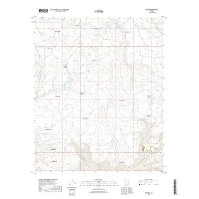
2018 Map of Maverick
USGS Topo · Published 2018About this map
Maverick sits at the northern edge of this high-elevation landscape, where the topography is defined by an intricate network of cienegas—unique mountain wetlands—and seasonal drainages. The map details a transition from the higher meadows of Odart Cienega and Sheep Cienega down toward the Black River, which forms part of the southern boundary between Apache and Graham counties. This area is characterized by its vital water management features, including Salt House Tank, McDonald Tank, and the descriptively named Battleground Number One Tank. These man-made improvements, alongside natural features like Tonto Lake and Ess Spring, highlight the region's importance for cattle ranching and wildlife in a region otherwise dominated by steep drainages like Pacheta Cr and Milk Cr. Significant landmarks such as Rattlesnake Point and Paddy Butte provide clear navigational markers across the varied terrain.
Find a feature on this map
44 named features on this map. Tap any name to fly to it.
Don’t see what you’re looking for? This feature index may not catch every label — zoom into the map to look around manually.
Map Details
Editions of this 2018 Maverick Map
This is the sole edition of this map. No revisions or reprints were ever made.
Other maps of this area

1922 · Nutrioso
USGS Topo · 1:125,000

1954 · Clifton
USGS Topo · 1:250,000

1957 · Clifton
USGS Topo · 1:250,000

1958 · Clifton
USGS Topo · 1:250,000

1958 · Hannagan Meadow
USGS Topo · 1:62,500

1958 · Big Lake
USGS Topo · 1:62,500

1962 · Clifton
USGS Topo · 1:250,000

1967 · Marshall Butte
USGS Topo · 1:24,000

1967 · Freezeout Mountain
USGS Topo · 1:24,000
1967 · Maverick SW
USGS Topo · 1:24,000