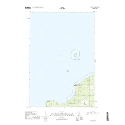
2018 Map of Mawikwe Bay
USGS Topo · Published 2018About this map
Apostle Islands National Lakeshore dominates the rugged shoreline of Lake Superior in this northern Wisconsin coastal survey. The map details the transition from the deep waters of the lake to the densely wooded bluffs along Mawikwe Bay. Of particular interest is the lone prominence of Eagle Island, situated north of the Eagle Island Shoals and protected as part of the Apostle Islands archipelago. The shoreline geography is defined by landmarks like Squaw Point and the drainage of Saxine Cr. On the mainland, a network of local corridors such as Mawikwe Rd and Eagle Island Rd provides access to the coastal bluffs, reflecting the contemporary land use and conservation boundaries of Bayfield County. This digital study provides a precise look at the interface between the lake’s natural features and the inland road network established by the 21st century.
Find a feature on this map
18 named features on this map. Tap any name to fly to it.
Don’t see what you’re looking for? This feature index may not catch every label — zoom into the map to look around manually.
Map Details
Editions of this 2018 Mawikwe Bay Map
This is the sole edition of this map. No revisions or reprints were ever made.
Other maps of this area

1941 · Bayfield
USGS Topo · 1:48,000

1944 · Cornucopia
USGS Topo · 1:48,000

1946 · Cornucopia
USGS Topo · 1:48,000

1946 · Bayfield
USGS Topo · 1:48,000

1953 · Ashland
USGS Topo · 1:250,000

1954 · Two Harbors
USGS Topo · 1:250,000

1957 · Two Harbors
USGS Topo · 1:250,000

1958 · Ashland
USGS Topo · 1:250,000

1958 · Two Harbors
USGS Topo · 1:250,000

1964 · Two Harbors
USGS Topo · 1:250,000