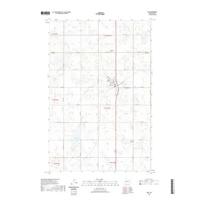
2020 Map of Max
USGS Topo · Published 2020About this map
The town of Max serves as a central hub in this prairie landscape, situated right at the boundary of Ward and McLean counties. The map reveals a community deeply rooted in its local heritage, evidenced by a high density of burial grounds surrounding the settlement. These sites, such as the First Baptist Russian Cem and the Old Max City Cem, hint at the diverse ethnic and religious groups, including Russian and Lutheran settlers, who established the agricultural foundations of this region. Outside the immediate township, the terrain is defined by numerous small depressions and water bodies, most notably Shallow Lake. The presence of the Semchenko Airport to the southeast reflects the importance of regional aviation in this expansive North Dakota countryside, while a strict grid of section-line roads like 26th St NW and 373rd Ave SW organizes the farmland.
Find a feature on this map
29 named features on this map. Tap any name to fly to it.
Don’t see what you’re looking for? This feature index may not catch every label — zoom into the map to look around manually.
Map Details
Editions of this 2020 Max Map
This is the sole edition of this map. No revisions or reprints were ever made.
Other maps of this area

1922 · Garrison
USGS Topo · 1:62,500

1929 · Coleharbor
USGS Topo · 1:62,500

1929 · Benedict
USGS Topo · 1:62,500

1954 · McClusky
USGS Topo · 1:250,000

1958 · McClusky
USGS Topo · 1:250,000
1974 · Garrison NW
USGS Topo · 1:24,000
1974 · Benedict NW
USGS Topo · 1:24,000
1974 · Benedict SW
USGS Topo · 1:24,000
1974 · Garrison NE
USGS Topo · 1:24,000
1974 · Coleharbor NW
USGS Topo · 1:24,000