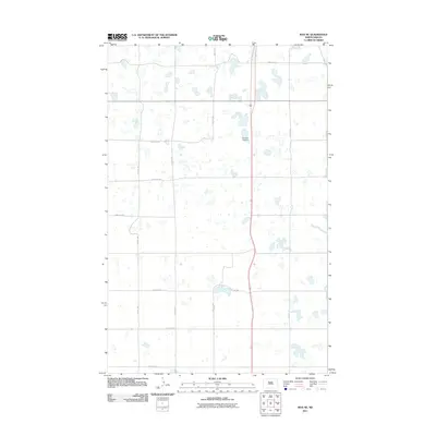
2011 Map of Max NE
USGS Topo · Published 2011About this map
Township Cemetery serves as a central landmark in this portion of Ward County, situated amidst a landscape defined by glacial prairie potholes and an extensive section-line road network. The grid of rural routes, including 233rd Ave SE and 345th Ave SW, illustrates the persistence of the Public Land Survey System in organizing the North Dakota plains. Long arterial roads like 18th St SW and 46th St SW connect isolated farmsteads and agricultural plots, while the numerous small, unnamed wetlands scattered throughout the quadrangle highlight the area's characteristic drainage patterns. This 2011 survey by the U.S. Geological Survey documents the region's rural character and the enduring infrastructure of the northern Great Plains during the early 21st century.
Find a feature on this map
13 named features on this map. Tap any name to fly to it.
Don’t see what you’re looking for? This feature index may not catch every label — zoom into the map to look around manually.
Map Details
Editions of this 2011 Max NE Map
This is the sole edition of this map. No revisions or reprints were ever made.
Other maps of this area

1928 · Minot
USGS Topo · 1:62,500

1929 · Sawyer
USGS Topo · 1:62,500

1929 · Benedict
USGS Topo · 1:62,500

1949 · Sawyer
USGS Topo · 1:62,500
1950 · Sawyer SW
USGS Topo · 1:24,000

1954 · Minot
USGS Topo · 1:250,000

1954 · McClusky
USGS Topo · 1:250,000

1958 · McClusky
USGS Topo · 1:250,000

1958 · Minot
USGS Topo · 1:250,000
1974 · Benedict NW
USGS Topo · 1:24,000