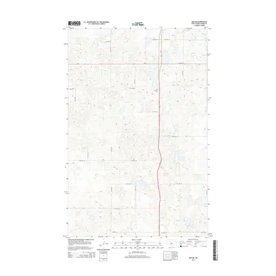
2014 Map of Max NE
USGS Topo · Published 2014About this map
Glacial pothole topography and a strictly ordered section-line road grid define this portion of Ward County in the mid-2010s. The landscape is characterized by a dense concentration of small depressions and seasonal wetlands typical of the Missouri Coteau region. Us-83 serves as the primary north-south artery, intersecting with ND-23 in the northern part of the quadrangle. Local history is anchored by the presence of Township Cem, located along the highway, which stands as a quiet marker of the rural community's heritage. In the northeast corner, Nelson Lake provides a rare larger water feature amidst the thousands of smaller prairie potholes. The survey meticulously details the extensive network of local roads, such as 233rd Ave SW and 345th Ave SE, reflecting the persistent 19th-century land division patterns that still govern the modern agricultural landscape.
Find a feature on this map
22 named features on this map. Tap any name to fly to it.
Don’t see what you’re looking for? This feature index may not catch every label — zoom into the map to look around manually.
Map Details
Editions of this 2014 Max NE Map
This is the sole edition of this map. No revisions or reprints were ever made.
Other maps of this area

1928 · Minot
USGS Topo · 1:62,500

1929 · Sawyer
USGS Topo · 1:62,500

1929 · Benedict
USGS Topo · 1:62,500

1949 · Sawyer
USGS Topo · 1:62,500
1950 · Sawyer SW
USGS Topo · 1:24,000

1954 · Minot
USGS Topo · 1:250,000

1954 · McClusky
USGS Topo · 1:250,000

1958 · McClusky
USGS Topo · 1:250,000

1958 · Minot
USGS Topo · 1:250,000
1974 · Benedict NW
USGS Topo · 1:24,000