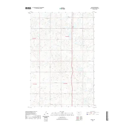
2020 Map of Max NE
USGS Topo · Published 2020About this map
The Gasman Township Cem serves as a central landmark in this portion of Ward County, reflecting the deep-rooted agricultural settlement of the North Dakota prairie. This landscape is defined by the Public Land Survey System, with township boundaries for t152n r83w, t152n r84w, t151n r83w, and t151n r84w creating a precise grid for local commerce and travel. The area's transport network relies on a strict section-line road system, including Co Hwy 22 and Co Hwy 24, which connect the scattered farmsteads of the region. Dozens of small wetlands and prairie potholes are dispersed across the terrain, illustrating the typical hydrography of the Missouri Plateau. Local movement is facilitated by thoroughfares like 2nd St Sw and 317th Ave Sw, which anchor the rural geography of this high plains township.
Find a feature on this map
22 named features on this map. Tap any name to fly to it.
Don’t see what you’re looking for? This feature index may not catch every label — zoom into the map to look around manually.
Map Details
Editions of this 2020 Max NE Map
This is the sole edition of this map. No revisions or reprints were ever made.
Other maps of this area

1928 · Minot
USGS Topo · 1:62,500

1929 · Sawyer
USGS Topo · 1:62,500

1929 · Benedict
USGS Topo · 1:62,500

1949 · Sawyer
USGS Topo · 1:62,500
1950 · Sawyer SW
USGS Topo · 1:24,000

1954 · Minot
USGS Topo · 1:250,000

1954 · McClusky
USGS Topo · 1:250,000

1958 · McClusky
USGS Topo · 1:250,000

1958 · Minot
USGS Topo · 1:250,000
1974 · Benedict NW
USGS Topo · 1:24,000