
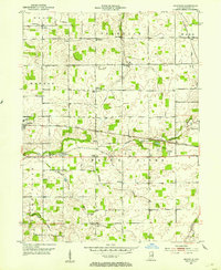
1952 Map of Maxville
USGS Topo · Published 1953About this map
The White River provides the central axis for this mid-century portrait of Randolph County, where the agricultural landscape is densely dotted with the institutions of rural Indiana life. The town of Farmland and the smaller settlement of Maxville anchor the central corridor, while a network of country churches like Olive Branch Ch and Dunkirk Ch serve the surrounding townships. Distinctive landmarks of the era include Funks Speedway and the Moorman Orphanage, alongside infrastructure such as a small Airstrip and several rural schools like Lincoln Sch.
Find a feature on this map
39 named features on this map. Tap any name to fly to it.
Don’t see what you’re looking for? This feature index may not catch every label — zoom into the map to look around manually.
Map Details
Editions of this 1952 Maxville Map
2 editions found
Other maps of this area

1915 · Fort Recovery
USGS Topo · 1:48,000

1916 · Winchester
USGS Topo · 1:48,000

1918 · Winchester
USGS Topo · 1:62,500

1918 · Fort Recovery
USGS Topo · 1:62,500

1943 · Winchester
USGS Topo · 1:62,500

1952 · Farmland
USGS Topo · 1:24,000

1953 · Muncie
USGS Topo · 1:250,000

1956 · Muncie
USGS Topo · 1:250,000

1960 · Carlos
USGS Topo · 1:24,000
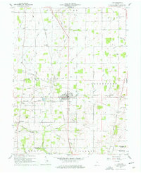
1960 · Lynn
USGS Topo · 1:24,000