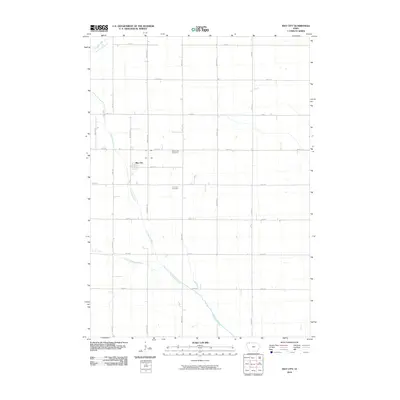
2010 Map of May City
USGS Topo · Published 2010About this map
May City serves as the central settlement in this portion of Osceola County, situated at the intersection of several local thoroughfares like Warbler Ave and 220th St. The landscape is largely defined by a grid of agricultural access roads and a drainage system that reflects the region's managed hydrology. The Ocheyedan River meanders across the territory from the northwest, joined further south by the Little Ocheyedan River, while engineering efforts are evident in the northern reaches via Judicial Ditch Number 64. For those tracing local roots or community history, the placement of the Mennonite Cemetery and Harrison Cemetery provides tangible links to the area's early families and religious congregations. The map illustrates a rural environment where natural waterways like Dry Run have been integrated into a highly structured section-line road network.
Find a feature on this map
23 named features on this map. Tap any name to fly to it.
Don’t see what you’re looking for? This feature index may not catch every label — zoom into the map to look around manually.
Map Details
Editions of this 2010 May City Map
This is the sole edition of this map. No revisions or reprints were ever made.
Other maps of this area

1954 · Fairmont
USGS Topo · 1:250,000

1958 · Fairmont
USGS Topo · 1:250,000

1964 · Plessis
USGS Topo · 1:24,000

1970 · Everly
USGS Topo · 1:24,000

1970 · Hartley
USGS Topo · 1:24,000

1970 · Lake Park SE
USGS Topo · 1:24,000

1970 · May City
USGS Topo · 1:24,000

1970 · Harris
USGS Topo · 1:24,000
1970 · Lake Park
USGS Topo · 1:24,000

1972 · Ocheyedan
USGS Topo · 1:24,000