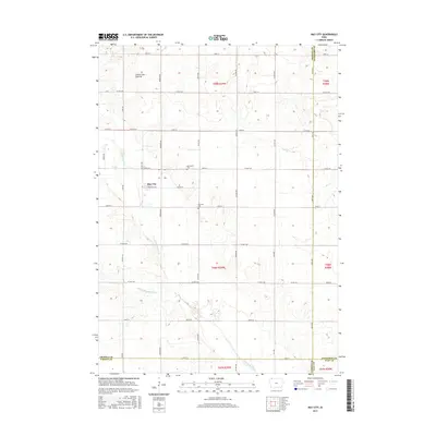
2015 Map of May City
USGS Topo · Published 2015About this map
The May City settlement and its agricultural surroundings are defined by the glacial landforms of the Coteau des Prairies, an upland plateau that divides major drainage basins in the Upper Midwest. The terrain is marked by the winding paths of the Ocheyedan River and the Little Ocheyedan River, which cut through the northwest-to-southeast landscape. The small community of May City sits near the headwaters of these river systems, serving as a hub for the local township. Researchers can trace rural lineages through local landmarks such as Mennonite Cem and Harrison Cem, located along the grid of county roads that crisscross the prairie. This 2015 survey illustrates the enduring nature of the section-line road system and the intersection of four counties—Osceola, Dickinson, O'Brien, and Clay—which meet at the southeast corner of this quadrangle.
Find a feature on this map
43 named features on this map. Tap any name to fly to it.
Don’t see what you’re looking for? This feature index may not catch every label — zoom into the map to look around manually.
Map Details
Editions of this 2015 May City Map
This is the sole edition of this map. No revisions or reprints were ever made.
Other maps of this area

1954 · Fairmont
USGS Topo · 1:250,000

1958 · Fairmont
USGS Topo · 1:250,000

1964 · Plessis
USGS Topo · 1:24,000

1970 · Everly
USGS Topo · 1:24,000

1970 · Hartley
USGS Topo · 1:24,000

1970 · Lake Park SE
USGS Topo · 1:24,000

1970 · May City
USGS Topo · 1:24,000

1970 · Harris
USGS Topo · 1:24,000
1970 · Lake Park
USGS Topo · 1:24,000

1972 · Ocheyedan
USGS Topo · 1:24,000