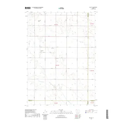
2018 Map of May City
USGS Topo · Published 2018About this map
The May City settlement occupies a central position on this Osceola County landscape, situated where the glacial highlands of the Coteau des Prairies meet the river valleys of northwest Iowa. The drainage pattern is defined by the southward flow of the Ocheyedan River and the Little Ocheyedan River, which create subtle topographic relief against the surrounding agricultural grid. This 2018 survey reveals the persistent presence of local heritage sites, including the Mennonite Cem located just east of the village and the Harrison Cem further south. The map provides a look at the modern rural infrastructure, where a network of numbered roads like Co Hwy M20 and Co Hwy A34 serves the farmsteads and connects the Osceola, Dickinson, O'Brien, and Clay county borders. The northernmost section is crossed by the seasonal channel of Dry Run, illustrating the headwater hydrology of this prairie region.
Find a feature on this map
41 named features on this map. Tap any name to fly to it.
Don’t see what you’re looking for? This feature index may not catch every label — zoom into the map to look around manually.
Map Details
Editions of this 2018 May City Map
This is the sole edition of this map. No revisions or reprints were ever made.
Other maps of this area

1954 · Fairmont
USGS Topo · 1:250,000

1958 · Fairmont
USGS Topo · 1:250,000

1964 · Plessis
USGS Topo · 1:24,000

1970 · Everly
USGS Topo · 1:24,000

1970 · Hartley
USGS Topo · 1:24,000

1970 · Lake Park SE
USGS Topo · 1:24,000

1970 · May City
USGS Topo · 1:24,000

1970 · Harris
USGS Topo · 1:24,000
1970 · Lake Park
USGS Topo · 1:24,000

1972 · Ocheyedan
USGS Topo · 1:24,000