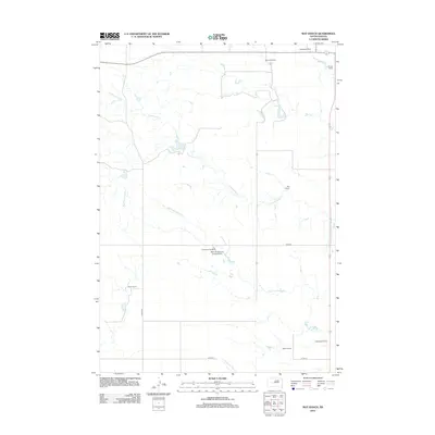
2012 Map of May Ranch
USGS Topo · Published 2012About this map
May Ranch and numerous other family-held ranching operations define this pastoral landscape in South Dakota's Haakon County. The 2012 topography shows a drainage system primarily composed of Big Prairie Dog Cr and Cottonwood Cr, which carve through the plains. The map reveals the logistical infrastructure of modern ranch life, including the private Gene Armstrong Landing Strip located near the Diamond Ring Ranch. Roads such as 214th St and 245th Ave create a grid-like network across the terrain, connecting disparate homesteads including the Standiford Ranch and Nemec Ranch. This survey provides a precise record of land use and water access in the early 21st century, illustrating how named drainages like Plum Cr and Little Prairie Dog Cr anchor the geographic identity of these rural western landholdings.
Find a feature on this map
16 named features on this map. Tap any name to fly to it.
Don’t see what you’re looking for? This feature index may not catch every label — zoom into the map to look around manually.
Map Details
Editions of this 2012 May Ranch Map
This is the sole edition of this map. No revisions or reprints were ever made.
Other maps of this area

1954 · Pierre
USGS Topo · 1:250,000

1958 · Pierre
USGS Topo · 1:250,000

1982 · Hayes South
USGS Topo · 1:24,000
1982 · Midland NE
USGS Topo · 1:24,000

1982 · Midland NW
USGS Topo · 1:24,000

1982 · May Ranch
USGS Topo · 1:24,000

1983 · Bentley Ranch
USGS Topo · 1:24,000

1983 · Hayes North
USGS Topo · 1:24,000

1983 · Philip
USGS Topo · 1:100,000

1983 · Moenville
USGS Topo · 1:24,000