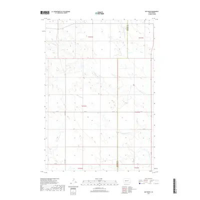
2017 Map of May Ranch
USGS Topo · Published 2017About this map
May Ranch sits within the high plains of central South Dakota, marking a point of human settlement in a landscape defined by an intricate network of drainage systems. The terrain is deeply etched by the seasonal flow of Cottonwood Cr and Plum Cr, which carve through the dry grassland before crossing the Haakon and Stanley county line. The map reveals a remote ranching economy dependent on reliable water access, as seen in the positioning of buildings relative to the riparian corridors and the winding path of Big Prairie Dog Cr. Development is sparse, consisting primarily of section roads like Dusty Ridge Rd and township lines that organize this portion of the northern Great Plains into a geometric grid.
Find a feature on this map
16 named features on this map. Tap any name to fly to it.
Don’t see what you’re looking for? This feature index may not catch every label — zoom into the map to look around manually.
Map Details
Editions of this 2017 May Ranch Map
This is the sole edition of this map. No revisions or reprints were ever made.
Other maps of this area

1954 · Pierre
USGS Topo · 1:250,000

1958 · Pierre
USGS Topo · 1:250,000

1982 · Hayes South
USGS Topo · 1:24,000
1982 · Midland NE
USGS Topo · 1:24,000

1982 · Midland NW
USGS Topo · 1:24,000

1982 · May Ranch
USGS Topo · 1:24,000

1983 · Bentley Ranch
USGS Topo · 1:24,000

1983 · Hayes North
USGS Topo · 1:24,000

1983 · Philip
USGS Topo · 1:100,000

1983 · Moenville
USGS Topo · 1:24,000