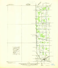
1936 Map of Maybee
USGS Topo · Published 1936About this map
Maybee sits at the intersection of industry and agriculture in this 1936 survey, where the Detroit Toledo & Ironton RR cuts a diagonal path through the southeastern corner of the quadrangle. The landscape is defined by an intricate network of drainage channels, including Bradshaw Drain and Capernall Drain, which reflect the historical effort to manage the flat terrain of Monroe and Wayne counties for farming. Small local schoolhouses like Clayton Sch, Columbia Sch, and Palmer Sch serve the scattered rural population across the townships of Sumpter, Augusta, and Exeter. Genealogists will find interest in the documented locations of Maybee Cem and Sandy Hill Cem, while the course of Stony Creek and the South Br Sandy Creek provide natural landmarks amidst the grid of country roads.
Find a feature on this map
67 named features on this map. Tap any name to fly to it.
Don’t see what you’re looking for? This feature index may not catch every label — zoom into the map to look around manually.
Map Details
Editions of this 1936 Maybee Map
This is the sole edition of this map. No revisions or reprints were ever made.
Other maps of this area

1902 · Ypsilanti
USGS Topo · 1:62,500

1904 · Ann Arbor
USGS Topo · 1:125,000

1906 · Ypsilanti
USGS Topo · 1:62,500

1906 · Romulus
USGS Topo · 1:62,500

1908 · Ann Arbor
USGS Topo · 1:125,000

1912 · Monroe
USGS Topo · 1:62,500

1912 · Dundee
USGS Topo · 1:62,500

1914 · Monroe
USGS Topo · 1:62,500

1926 · Dundee
USGS Topo · 1:62,500

1927 · Monroe
USGS Topo · 1:31,680
Featured Places
- Sumpter Township, MI
- Augusta Charter Township, MI
- Exeter Township, MI
- London, London Township
- London Township, MI