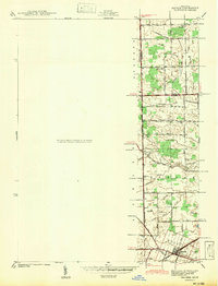
1942 Map of Maybee
USGS Topo · Published 1942About this map
Maybee serves as the focal point of this 1940s landscape, situated at the junction of the London, Exeter, and Raisinville townships. The area is defined by a dense network of agricultural drainage systems, including the Bradshaw Drain and Bitz Drain, which channel water toward the larger branches of Stony Creek and Swan Creek. This reliance on artificial drainage suggests a history of reclaiming fertile marshland for farming, a common development pattern in southeastern Michigan. Local centers of community life are captured in the distribution of rural institutions like the Clayton Sch, Columbia Sch, and Palmer Sch. Genealogists will find the Sandy Hill Cem near the intersection of Stony Road and Stout Rd, while the northern border with Wayne Co shows the small settlement of West Sumpter as it appeared before mid-century expansion.
Find a feature on this map
57 named features on this map. Tap any name to fly to it.
Don’t see what you’re looking for? This feature index may not catch every label — zoom into the map to look around manually.
Map Details
Editions of this 1942 Maybee Map
This is the sole edition of this map. No revisions or reprints were ever made.
Other maps of this area

1902 · Ypsilanti
USGS Topo · 1:62,500

1904 · Ann Arbor
USGS Topo · 1:125,000

1906 · Ypsilanti
USGS Topo · 1:62,500

1906 · Romulus
USGS Topo · 1:62,500

1908 · Ann Arbor
USGS Topo · 1:125,000

1912 · Monroe
USGS Topo · 1:62,500

1912 · Dundee
USGS Topo · 1:62,500

1914 · Monroe
USGS Topo · 1:62,500

1926 · Dundee
USGS Topo · 1:62,500

1927 · Monroe
USGS Topo · 1:31,680
Featured Places
- Sumpter Township, MI
- Augusta Charter Township, MI
- Exeter Township, MI
- London, London Township
- London Township, MI