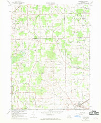
1967 Map of Maybee
USGS Topo · Published 1969About this map
Agricultural reaches of the Washtenaw and Monroe County line define this landscape, where the Saline River and a network of drains like Swan Creek and Sandy Creek cut through the flat terrain. The village of Maybee sits at a rail junction in the southeast, while the Detroit Toledo and Ironton railroad tracks provide a transit spine for the rural communities of London and Oakville. A notable historic marker on this sheet is the Old Indian Treaty Boundary, which runs along the southern edge, bisecting the survey area. Local heritage is concentrated at nodes like Bethlehem Ch and the Metropolitan Memorial Park Cemetery, reflecting a settled landscape of small schools such as Brainard Sch and localized industry including a Quarry near the eastern border.
Find a feature on this map
62 named features on this map. Tap any name to fly to it.
Don’t see what you’re looking for? This feature index may not catch every label — zoom into the map to look around manually.
Map Details
Editions of this 1967 Maybee Map
This is the sole edition of this map. No revisions or reprints were ever made.
Other maps of this area

1902 · Ypsilanti
USGS Topo · 1:62,500

1904 · Ann Arbor
USGS Topo · 1:125,000

1906 · Ypsilanti
USGS Topo · 1:62,500

1906 · Romulus
USGS Topo · 1:62,500

1908 · Ann Arbor
USGS Topo · 1:125,000

1912 · Monroe
USGS Topo · 1:62,500

1912 · Dundee
USGS Topo · 1:62,500

1914 · Monroe
USGS Topo · 1:62,500

1926 · Dundee
USGS Topo · 1:62,500

1927 · Monroe
USGS Topo · 1:31,680
Featured Places
- Sumpter Township, MI
- Augusta Charter Township, MI
- Exeter Township, MI
- London, London Township
- London Township, MI