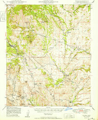
1949 Map of Mayer
USGS Topo · Published 1949About this map
Mayer and the neighboring settlements of Cordes and Cleator anchor this survey of Yavapai County, highlighting a landscape defined by ranching and hard-rock mining. The Agua Fria River cuts through the territory, flanked by a dense network of mineral claims that drove the local economy in the mid-20th century. Notable operations like the Blue Bell Mine, Golden Turkey Mine, and St Johns Mine are mapped alongside the At&SF RR, which provided the vital transportation link for ore and supplies. Beyond the industrial sites, family-named locales such as the Griffin and Bennett Ranch and El Rancho del Rosas reveal the domestic footprint of the era. The presence of a small Cem near Mayer and various Corral sites underscore the dual nature of this high-desert region as both a mining hub and a ranching frontier.
Find a feature on this map
72 named features on this map. Tap any name to fly to it.
Don’t see what you’re looking for? This feature index may not catch every label — zoom into the map to look around manually.
Map Details
Editions of this 1949 Mayer Map
2 editions found
Other maps of this area

1887 · Verde
USGS Topo · 1:250,000

1887 · Prescott
USGS Topo · 1:250,000

1892 · Verde
USGS Topo · 1:250,000

1892 · Prescott
USGS Topo · 1:250,000

1903 · Bradshaw Mountains
USGS Topo · 1:125,000

1905 · Jerome
USGS Topo · 1:125,000

1923 · Camp Verde
USGS Topo · 1:125,000

1929 · Turret Peak
USGS Topo · 1:125,000

1932 · Camp Verde
USGS Topo · 1:125,000

1933 · Turret Peak
USGS Topo · 1:125,000