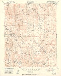
1949 Map of Mayer
USGS Topo · Published 1949About this map
The Agua Fria River cuts a deep path through this 1940s landscape, where the primary industry of the era is evidenced by a dense network of mining operations. The settlement of Mayer serves as a northern hub, linked by the A T & S F railroad to smaller outposts like Cleator and Cordes. This survey, produced by the Forest Service, documents a hardscrabble mining district before the modern expansion of regional highways, revealing a landscape etched with numerous family-named ranches such as Roy Ranch, Burmister Ranch, and the Quarter Circle V Bar Ranch.
Find a feature on this map
74 named features on this map. Tap any name to fly to it.
Don’t see what you’re looking for? This feature index may not catch every label — zoom into the map to look around manually.
Map Details
Editions of this 1949 Mayer Map
2 editions found
Other maps of this area

1887 · Verde
USGS Topo · 1:250,000

1887 · Prescott
USGS Topo · 1:250,000

1892 · Verde
USGS Topo · 1:250,000

1892 · Prescott
USGS Topo · 1:250,000

1903 · Bradshaw Mountains
USGS Topo · 1:125,000

1905 · Jerome
USGS Topo · 1:125,000

1923 · Camp Verde
USGS Topo · 1:125,000

1929 · Turret Peak
USGS Topo · 1:125,000

1932 · Camp Verde
USGS Topo · 1:125,000

1933 · Turret Peak
USGS Topo · 1:125,000