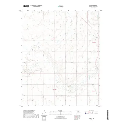
2018 Map of Mayfield
USGS Topo · Published 2018About this map
Mayfield serves as the primary settlement center on this Oklahoma landscape, which is defined by the braided and meandering course of the N Fork Red River. The river's broad valley dominates the southern half of the map, creating a complex network of wetlands and shifting channels. To the east, Tittle Bridge provides a crossing point near the township line, while several drainage systems including Sweetwater Cr and Salt Cr feed into the river from the north. The rectangular survey system is clearly established here, with an extensive network of section-line roads like N1700 Rd and E1170 Rd framing the agricultural plots. Local history is anchored at the Mayfield Cem, which remains a significant genealogical landmark for Beckham County researchers tracking family ties to the western plains.
Find a feature on this map
34 named features on this map. Tap any name to fly to it.
Don’t see what you’re looking for? This feature index may not catch every label — zoom into the map to look around manually.
Map Details
Editions of this 2018 Mayfield Map
This is the sole edition of this map. No revisions or reprints were ever made.
Other maps of this area

1954 · Amarillo
USGS Topo · 1:250,000

1955 · Clinton
USGS Topo · 1:250,000

1957 · Clinton
USGS Topo · 1:250,000

1958 · Amarillo
USGS Topo · 1:250,000

1960 · Sweetwater
USGS Topo · 1:62,500

1961 · Erick
USGS Topo · 1:62,500

1962 · Kelton SE
USGS Topo · 1:24,000

1963 · Kelton
USGS Topo · 1:24,000

1963 · Fulller
USGS Topo · 1:24,000
1983 · Shamrock
USGS Topo · 1:100,000