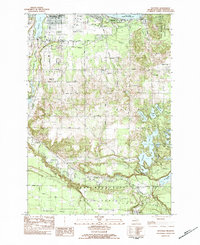
1983 Map of Mayfield
USGS Topo · Published 1984About this map
Traverse City anchors the northern reach of this survey, where the East Arm Grand Traverse Bay meets a landscape of rapid mid-century growth and aviation infrastructure. The map documents the Cherry Capital Municipal Airport and the adjacent US Coast Guard Air Station, while the Michigan Northern railroad corridor tracks south through the Boardman River valley. To the south, the terrain transitions into the dense woodlands of the Pere Marquette State Forest, interrupted by a complex of recreational waters including Arbutus Lake and Spider Lake. The placement of institutions like the Vocational Sch and Traverse Heights Sch near the bay illustrates the city's inland expansion during the early 1980s, while the southern settlement of Mayfield remains a quiet outpost on the edge of the Weidenhamer Swamp.
Find a feature on this map
41 named features on this map. Tap any name to fly to it.
Don’t see what you’re looking for? This feature index may not catch every label — zoom into the map to look around manually.
Map Details
Editions of this 1983 Mayfield Map
2 editions found
Other maps of this area

1954 · Traverse City
USGS Topo · 1:250,000

1956 · Fife Lake
USGS Topo · 1:62,500

1956 · Kingsley
USGS Topo · 1:62,500

1957 · Traverse City
USGS Topo · 1:62,500

1957 · Elk Rapids
USGS Topo · 1:62,500

1958 · Traverse City
USGS Topo · 1:250,000

1983 · Buckley
USGS Topo · 1:25,000

1983 · Traverse City SE
USGS Topo · 1:25,000

1983 · Traverse City
USGS Topo · 1:100,000
1983 · Grawn
USGS Topo · 1:25,000
Featured Places
- Garfield Township, MI
- Traverse City, MI
- East Bay Township, MI
- East Bay Charter Township, East Bay Township
- Blair Township, MI