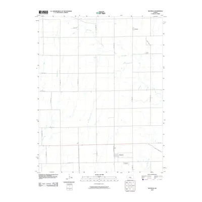
2010 Map of Mayfield
USGS Topo · Published 2010About this map
Mayfield sits at the heart of this agricultural landscape in Sumner County, defined by a rigid grid of section roads and the winding paths of prairie waterways. This 2010 survey illustrates the enduring rural character of the region, where the small community of Anson anchors the northern portion of the quadrangle. The topography is shaped by the drainage systems of Slate Creek and Beaver Creek, along with the West Prairie Creek and East Prairie Creek tributaries. These natural watercourses provide a stark contrast to the straight-line geometry of thoroughfares like N Sumner Rd and W 40th Ave N. For those tracing local history or family ties, the map provides precise locations for the Austin Cemetery and the Township Cemetery, which serve as permanent markers of the area's settlement history amidst the productive Kansas farmland.
Find a feature on this map
28 named features on this map. Tap any name to fly to it.
Don’t see what you’re looking for? This feature index may not catch every label — zoom into the map to look around manually.
Map Details
Editions of this 2010 Mayfield Map
This is the sole edition of this map. No revisions or reprints were ever made.
Other maps of this area

1889 · Caldwell
USGS Topo · 1:125,000

1890 · Wellington
USGS Topo · 1:125,000

1893 · Caldwell
USGS Topo · 1:125,000

1897 · Caldwell
USGS Topo · 1:125,000
1955 · Zyba
USGS Topo · 1:24,000

1955 · Wichita
USGS Topo · 1:250,000

1958 · Wichita
USGS Topo · 1:250,000

1965 · Rome
USGS Topo · 1:24,000
1965 · Wellington
USGS Topo · 1:24,000

1971 · Caldwell NW
USGS Topo · 1:24,000