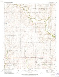
1971 Map of Mayfield
USGS Topo · Published 1973About this map
Mayfield and the smaller settlement of Anson anchor this rural landscape in the early 1970s, illustrating the agricultural and rail-dependent character of Sumner County. The area is defined by its drainage systems, most notably Slate Creek which meanders through the northeast, and the convergence of West Prairie Creek and East Prairie Creek to the south. Two major rail lines cross the territory: the Missouri Pacific near the northern boundary and the Atchison Topeka and Santa Fe passing through the heart of Mayfield. This rail connectivity emphasizes the importance of these small hubs for the movement of grain and goods. Local history is preserved at Austin Cem and Township Cem, while scattered Oil Wells across the western townships indicate the region's energy production history alongside traditional farming.
Find a feature on this map
18 named features on this map. Tap any name to fly to it.
Don’t see what you’re looking for? This feature index may not catch every label — zoom into the map to look around manually.
Map Details
Editions of this 1971 Mayfield Map
This is the sole edition of this map. No revisions or reprints were ever made.
Other maps of this area

1889 · Caldwell
USGS Topo · 1:125,000

1890 · Wellington
USGS Topo · 1:125,000

1893 · Caldwell
USGS Topo · 1:125,000

1897 · Caldwell
USGS Topo · 1:125,000
1955 · Zyba
USGS Topo · 1:24,000

1955 · Wichita
USGS Topo · 1:250,000

1958 · Wichita
USGS Topo · 1:250,000

1965 · Rome
USGS Topo · 1:24,000
1965 · Wellington
USGS Topo · 1:24,000

1971 · Caldwell NW
USGS Topo · 1:24,000