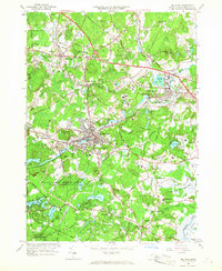
1965 Map of Maynard
USGS Topo · Published 1967About this map
The industrial and institutional character of mid-century Middlesex County is centered on Maynard, where the Assabet River winds through a landscape defined by manufacturing and state facilities. This mid-1960s perspective captures the busy rail corridor of the Boston and Maine and New York New Haven and Hartford railroads serving towns like West Acton and South Acton. Notable landmarks include the sprawling Concord Reformatory near West Concord and the specialized U S Military Reservation Natick Laboratories.
Find a feature on this map
99 named features on this map. Tap any name to fly to it.
Don’t see what you’re looking for? This feature index may not catch every label — zoom into the map to look around manually.
Map Details
Editions of this 1965 Maynard Map
3 editions found
Other maps of this area

1886 · Lowell
USGS Topo · 1:62,500

1886 · Framingham
USGS Topo · 1:62,500

1887 · Marlboro
USGS Topo · 1:62,500

1889 · Marlboro
USGS Topo · 1:62,500

1889 · Framingham
USGS Topo · 1:62,500

1893 · Lowell
USGS Topo · 1:62,500

1893 · Groton
USGS Topo · 1:62,500

1894 · Framingham
USGS Topo · 1:62,500

1896 · Marlboro
USGS Topo · 1:62,500

1898 · Marlboro
USGS Topo · 1:62,500