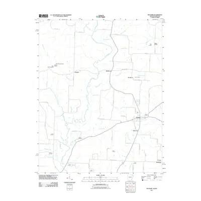
2011 Map of Maynard
USGS Topo · Published 2011About this map
The Fourche River meanders through this portion of Randolph County, anchoring a landscape defined by small clusters of settlement and numerous family-named landmarks. Maynard serves as the primary hub, surrounded by smaller locales like Old Siloam, Middlebrook, and Elkins Park. The terrain is marked by distinctive drainage features such as Rock Spring Hollow and Niccum Hollow, while the agricultural and social history of the area is preserved in the placement of many rural burial grounds, including the Maynard Cemetery, Barnett Cemetery, and Foster Cemetery. A network of historic roads and trails, such as Columbia Trl and Sioux Trl, connects these communities across the river valley, illustrating the enduring layout of rural Arkansas township life near the Missouri border.
Find a feature on this map
69 named features on this map. Tap any name to fly to it.
Don’t see what you’re looking for? This feature index may not catch every label — zoom into the map to look around manually.
Map Details
Editions of this 2011 Maynard Map
This is the sole edition of this map. No revisions or reprints were ever made.
Other maps of this area

1935 · Reyno
USGS Topo · 1:62,500

1939 · Doniphan
USGS Topo · 1:62,500

1941 · Gatewood
USGS Topo · 1:62,500

1945 · Doniphan
USGS Topo · 1:62,500

1945 · Gatewood
USGS Topo · 1:62,500

1957 · Poplar Bluff
USGS Topo · 1:250,000

1959 · Poplar Bluff
USGS Topo · 1:250,000

1960 · Poplar Bluff
USGS Topo · 1:250,000

1965 · Gatewood
USGS Topo · 1:24,000
1966 · Ravenden Springs SE
USGS Topo · 1:24,000