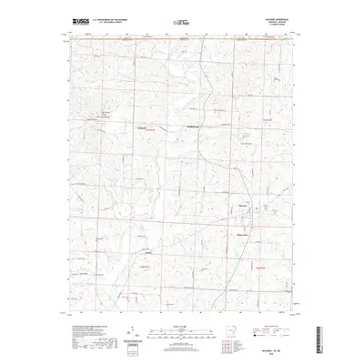
2020 Map of Maynard
USGS Topo · Published 2020About this map
The Fourche River flows southward through this Randolph County landscape, anchoring a series of small settlements and family-named cemeteries near the Missouri border. The community of Maynard sits as a focal point along HWY 328 E, surrounded by smaller locales like Elkins Park, Brakebill, and Middlebrook. Genealogists will find a high concentration of burial sites throughout the terrain, including the Maynard Cem, Siloam Cem, and Sparkman Cem, suggesting a long history of established family homesteads in the river valley.
Find a feature on this map
86 named features on this map. Tap any name to fly to it.
Don’t see what you’re looking for? This feature index may not catch every label — zoom into the map to look around manually.
Map Details
Editions of this 2020 Maynard Map
This is the sole edition of this map. No revisions or reprints were ever made.
Other maps of this area

1935 · Reyno
USGS Topo · 1:62,500

1939 · Doniphan
USGS Topo · 1:62,500

1941 · Gatewood
USGS Topo · 1:62,500

1945 · Doniphan
USGS Topo · 1:62,500

1945 · Gatewood
USGS Topo · 1:62,500

1957 · Poplar Bluff
USGS Topo · 1:250,000

1959 · Poplar Bluff
USGS Topo · 1:250,000

1960 · Poplar Bluff
USGS Topo · 1:250,000

1965 · Gatewood
USGS Topo · 1:24,000
1966 · Ravenden Springs SE
USGS Topo · 1:24,000