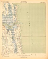
1918 Map of Mayport
USGS Topo · Published 1918About this map
St Johns River defines the landscape of this coastal Florida corridor during the late World War I era, serving as the primary artery between the inland marshes and the Atlantic Ocean. The survey captures the established maritime and resort communities of Duval County, including the fishing and piloting hub at Mayport and the early beachfront developments at Manhattan Beach and Pablo Beach. Inland, the terrain is a complex network of salt marshes and tidal creeks such as Pablo Creek and Sister Creek, punctuated by significant elevations like Mount Cornelia on Fort George Island.
Find a feature on this map
50 named features on this map. Tap any name to fly to it.
Don’t see what you’re looking for? This feature index may not catch every label — zoom into the map to look around manually.
Map Details
Editions of this 1918 Mayport Map
4 editions found
Other maps of this area

1917 · Orange Park
USGS Topo · 1:62,500

1918 · St Marys
USGS Topo · 1:62,500

1918 · Jacksonville
USGS Topo · 1:62,500

1918 · Orange Park
USGS Topo · 1:62,500

1918 · Palm Valley
USGS Topo · 1:62,500

1918 · Mayport
USGS Topo · 1:62,500

1919 · Fernandina
USGS Topo · 1:62,500

1919 · St Marys
USGS Topo · 1:62,500

1944 · Fernandina
USGS Topo · 1:62,500

1948 · Jacksonville
USGS Topo · 1:250,000