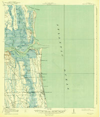
1918 Map of Mayport
USGS Topo · Published 1943About this map
Pilot Town Fort George PO and the fishing village of Mayport anchor this coastal landscape during a period of significant transition for the Florida shoreline. The survey reveals a complex network of barrier islands and salt marshes, including Talbot Island and Black Hammock Island, separated by the intricate Fort George River. Before the heavy development of the late 20th century, the coastal economy relied on the Florida East Coast railway, which reached the shore via the Mayport Br.
Find a feature on this map
55 named features on this map. Tap any name to fly to it.
Don’t see what you’re looking for? This feature index may not catch every label — zoom into the map to look around manually.
Map Details
Editions of this 1918 Mayport Map
4 editions found
Other maps of this area

1917 · Orange Park
USGS Topo · 1:62,500

1918 · St Marys
USGS Topo · 1:62,500

1918 · Jacksonville
USGS Topo · 1:62,500

1918 · Orange Park
USGS Topo · 1:62,500

1918 · Palm Valley
USGS Topo · 1:62,500

1918 · Mayport
USGS Topo · 1:62,500

1919 · Fernandina
USGS Topo · 1:62,500

1919 · St Marys
USGS Topo · 1:62,500

1944 · Fernandina
USGS Topo · 1:62,500

1948 · Jacksonville
USGS Topo · 1:250,000