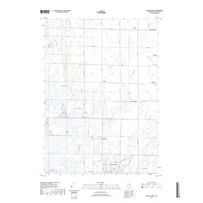
2018 Map of Mayville North
USGS Topo · Published 2018About this map
Mayville anchors the southern edge of this Dodge County landscape, where the East Branch Rock River flows toward the Lower Mayville Millpond 174. The western margin is dominated by the sprawling wetlands of Horicon Marsh, a significant natural feature broken only by artificial drainage systems like Townline Ditch and Clarks Ditch. This 2018 survey reveals a rural structure defined by small agricultural settlements and a network of county roads connecting Kekoskee, LeRoy, and Brownsville. Genealogists will find numerous family-history landmarks throughout the township, including several small burial grounds such as Mount Pleasant Cem, Emanuel Cem, and Tidyman Cem. The terrain includes subtle elevations such as Phils Island rising within the marsh and the limestone ledges found near Ledge Rd.
Find a feature on this map
70 named features on this map. Tap any name to fly to it.
Don’t see what you’re looking for? This feature index may not catch every label — zoom into the map to look around manually.
Map Details
Editions of this 2018 Mayville North Map
This is the sole edition of this map. No revisions or reprints were ever made.
Other maps of this area

1904 · Hartford
USGS Topo · 1:62,500

1955 · Waupun
USGS Topo · 1:62,500

1955 · Campbellsport
USGS Topo · 1:62,500

1955 · Horicon
USGS Topo · 1:62,500

1957 · Madison
USGS Topo · 1:250,000

1959 · Hartford
USGS Topo · 1:62,500

1959 · Nenno
USGS Topo · 1:24,000

1960 · Madison
USGS Topo · 1:250,000
1974 · Byron
USGS Topo · 1:24,000
1974 · Lomira
USGS Topo · 1:24,000