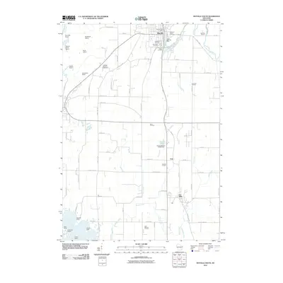
2010 Map of Mayville South
USGS Topo · Published 2010About this map
The East Branch Rock River anchors the northern settlement of Mayville, where the Upper Mayville Dam and the Mayville Post Office define the town's central corridor. This landscape in Dodge County is characterized by a high concentration of burial grounds, including the New Saint Marys Cemetery, Old Saint Marys Cemetery, and Graceland Cemetery, which are essential for genealogical research in this part of Wisconsin. Moving south toward Neda and Iron Ridge, the terrain is punctuated by small waterways like Neda Creek and Wildcat Creek. To the west, the Rock River broadens into a series of named islands and points, such as Fourmile Island, Indernuhle Island, and Radloff Point, indicating a complex riverine environment. The presence of features like Karsten Number 2 E5583 Dam and Karsten Number 1 E-5583 Dam illustrates the continued importance of water management and local hydrology in this agricultural and industrial region.
Find a feature on this map
83 named features on this map. Tap any name to fly to it.
Don’t see what you’re looking for? This feature index may not catch every label — zoom into the map to look around manually.
Map Details
Editions of this 2010 Mayville South Map
This is the sole edition of this map. No revisions or reprints were ever made.
Other maps of this area

1904 · Hartford
USGS Topo · 1:62,500

1955 · Waupun
USGS Topo · 1:62,500

1955 · Campbellsport
USGS Topo · 1:62,500

1955 · Horicon
USGS Topo · 1:62,500

1957 · Madison
USGS Topo · 1:250,000

1959 · Hartford
USGS Topo · 1:62,500

1959 · Nenno
USGS Topo · 1:24,000
1959 · Hartford West
USGS Topo · 1:24,000

1960 · Madison
USGS Topo · 1:250,000
1974 · Lomira
USGS Topo · 1:24,000