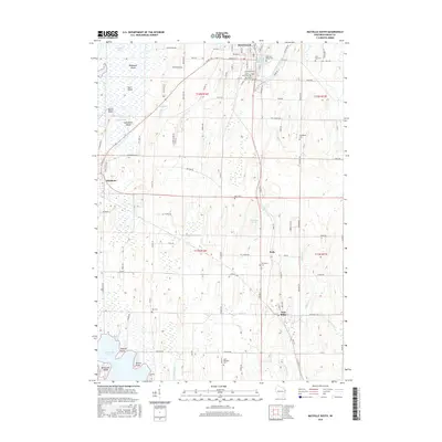
2015 Map of Mayville South
USGS Topo · Published 2015About this map
Mayville sits at the northern edge of this landscape, where the East Branch Rock River feeds the Mayville Millpond. This 2015 survey details a series of agricultural and industrial settlements, including Neda and Iron Ridge, connected by a network of rural roads such as W Neda Rd and Wildcat Rd. The terrain is defined by the expansive wetlands of the Horicon Marsh to the northwest and the northern reaches of Sinissippi Lake to the southwest, punctuated by named landforms like Rudebush Island, Koch Island, and Radloff Point. For genealogists, the map is particularly dense with burial sites, documenting Old Saint Marys Cem, Saint Johns Cem, and Graceland Cem, alongside smaller rural plots like Mace Cem and Rex Cem. Numerous waterways, including Wildcat Cr and Neda Cr, carve through the townships, reflecting the drainage patterns that shaped local land use and development.
Find a feature on this map
64 named features on this map. Tap any name to fly to it.
Don’t see what you’re looking for? This feature index may not catch every label — zoom into the map to look around manually.
Map Details
Editions of this 2015 Mayville South Map
This is the sole edition of this map. No revisions or reprints were ever made.
Other maps of this area

1904 · Hartford
USGS Topo · 1:62,500

1955 · Waupun
USGS Topo · 1:62,500

1955 · Campbellsport
USGS Topo · 1:62,500

1955 · Horicon
USGS Topo · 1:62,500

1957 · Madison
USGS Topo · 1:250,000

1959 · Hartford
USGS Topo · 1:62,500

1959 · Nenno
USGS Topo · 1:24,000
1959 · Hartford West
USGS Topo · 1:24,000

1960 · Madison
USGS Topo · 1:250,000
1974 · Lomira
USGS Topo · 1:24,000