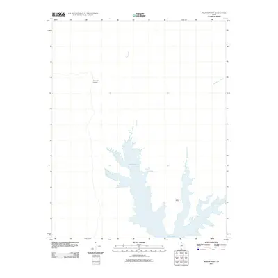
2011 Map of Mazuki Point
USGS Topo · Published 2011About this map
Lake Powell dominates the southern landscape of this Kane County region, its jagged shoreline reaching deep into the desert drainages. The map illustrates how the rising reservoir waters have transformed the natural topography, filling the lower reaches of Rock Creek and Middle Rock Creek. These desert waterways, once simple drainages, now form sprawling inlets that define the modern character of the area. Above the high-water line, the arid terrain remains defined by prominent landforms such as Mazuki Point and the steep walls of Twitchell Canyon. This 2011 survey captures the state of the canyon country decades after the damming of the Colorado River, showing the intricate relationship between the expansive lake and the remaining high desert plateaus.
Find a feature on this map
5 named features on this map. Tap any name to fly to it.
Don’t see what you’re looking for? This feature index may not catch every label — zoom into the map to look around manually.
Map Details
Editions of this 2011 Mazuki Point Map
This is the sole edition of this map. No revisions or reprints were ever made.
Other maps of this area

1886 · Escalante
USGS Topo · 1:250,000

1922 · Warm Creek
USGS Topo · 1:63,360

1922 · Rees Canyon
USGS Topo · 1:63,360

1953 · Cummings Mesa
USGS Topo · 1:62,500

1953 · Gunsight Butte
USGS Topo · 1:62,500

1956 · Escalante
USGS Topo · 1:250,000

1960 · Escalante
USGS Topo · 1:250,000

1968 · East of The Navajo
USGS Topo · 1:24,000
1968 · Blackburn Canyon
USGS Topo · 1:24,000
1968 · Sooner Bench
USGS Topo · 1:24,000