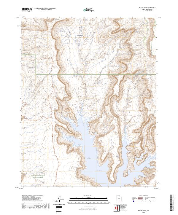
2023 Map of Mazuki Point
USGS Topo · Published 2023About this map
Lake Powell and its intricate shoreline dominate the southern half of this modern Kane County survey, illustrating the complex geography of the Glen Canyon National Recreation Area. The landscape is defined by the dramatic interface between the high desert plateau and the deep inlets of Rock Creek Bay. Historically significant landmarks like Woolsey Arch and the prominent Mazuki Point stand alongside rugged backcountry routes, including the Grand Bench Trl and Little Valley Road Trl. These trails provide the only terrestrial access through steep terrain like Twitchell Canyon. From the heights of Fiftymile Mountain to the remote waters of Middle Rock Creek, the map details a region where water management and wilderness recreation define the modern era.
Find a feature on this map
16 named features on this map. Tap any name to fly to it.
Don’t see what you’re looking for? This feature index may not catch every label — zoom into the map to look around manually.
Map Details
Editions of this 2023 Mazuki Point Map
This is the sole edition of this map. No revisions or reprints were ever made.
Other maps of this area

1886 · Escalante
USGS Topo · 1:250,000

1922 · Warm Creek
USGS Topo · 1:63,360

1922 · Rees Canyon
USGS Topo · 1:63,360

1953 · Cummings Mesa
USGS Topo · 1:62,500

1953 · Gunsight Butte
USGS Topo · 1:62,500

1956 · Escalante
USGS Topo · 1:250,000

1960 · Escalante
USGS Topo · 1:250,000

1968 · East of The Navajo
USGS Topo · 1:24,000
1968 · Blackburn Canyon
USGS Topo · 1:24,000
1968 · Sooner Bench
USGS Topo · 1:24,000