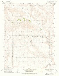
1969 Map of Mc Allaster
USGS Topo · Published 1977About this map
McAllaster anchors the southeastern corner of this Western Kansas landscape, situated along the vital Union Pacific railroad line. The terrain is defined by the winding course of the North Fork Smoky Hill River, which is joined by several tributaries including Sand Creek and Lake Creek. The topography reveals a series of breaks and draws typical of the High Plains, where the watercourses have carved distinct valleys into the tableland. Land use in the late 1960s appears centered on natural resource extraction and transportation, evidenced by the presence of a Marl Pit, a Gravel Pit, and a Sandpit scattered across the quadrangle. A network of Jeep Trails provides access through the more dissected areas north of the river, connecting remote Springs to the primary overland routes. The map also delineates the border between Wallace County and Logan County, showing how these political boundaries intersect with the natural drainage patterns of the region.
Find a feature on this map
13 named features on this map. Tap any name to fly to it.
Don’t see what you’re looking for? This feature index may not catch every label — zoom into the map to look around manually.
Map Details
Editions of this 1969 Mc Allaster Map
2 editions found
Other maps of this area

1954 · Goodland
USGS Topo · 1:250,000

1955 · Scott City
USGS Topo · 1:250,000

1956 · Goodland
USGS Topo · 1:250,000

1957 · Goodland
USGS Topo · 1:250,000

1958 · Scott City
USGS Topo · 1:250,000

1959 · Wallace
USGS Topo · 1:62,500

1959 · Harris Draw
USGS Topo · 1:62,500

1969 · Mc Allaster NW
USGS Topo · 1:24,000

1969 · Russell Springs 2 NW
USGS Topo · 1:24,000

1969 · Mc Allaster SE
USGS Topo · 1:24,000