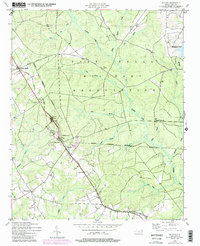
1948 Map of Mc Cain
USGS Topo · Published 1998About this map
The Fort Bragg Military Reservation dominates the northern half of this landscape, its boundary cutting through the heart of the region's diverse creek systems including Rockfish Creek and Piney Bottom Creek. A strong corridor of settlement and transport runs southeast from Ashley Heights through Mc Cain and Montrose, following the route of the Aberdeen and Rockfish railroad. These small communities, once vital stops on the rail line, are defined by local landmarks like the rail stop at Pooles Siding and the presence of community centers such as Sandy Grove Ch.
Find a feature on this map
30 named features on this map. Tap any name to fly to it.
Don’t see what you’re looking for? This feature index may not catch every label — zoom into the map to look around manually.
Map Details
Editions of this 1948 Mc Cain Map
3 editions found
Other maps of this area

1948 · Southern Pines
USGS Topo · 1:62,500

1948 · Clifdale
USGS Topo · 1:62,500

1948 · Pinebluff
USGS Topo · 1:24,000

1948 · Nicholson Creek
USGS Topo · 1:24,000

1948 · Mc Cain
USGS Topo · 1:24,000

1949 · Wagram
USGS Topo · 1:24,000

1949 · Silver Hill
USGS Topo · 1:24,000

1949 · Laurinburg
USGS Topo · 1:62,500

1950 · Sanatorium
USGS Topo · 1:24,000

1950 · Lobelia
USGS Topo · 1:24,000