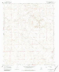
1966 Map of Mc Cloy Ranch
USGS Topo · Published 1984About this map
Mccloy Ranch serves as the central hub of this mid-1960s survey, illustrating the critical importance of groundwater infrastructure in the high plains of Eastern New Mexico. The landscape is defined by an extensive network of named water sources and a boundary between Harding Co and Quay Co. This arid environment relied on specifically identified wells to support ranching operations, such as Old Church Well, McCarty Well, and the East Chihuahua and West Chihuahua wells.
Find a feature on this map
26 named features on this map. Tap any name to fly to it.
Don’t see what you’re looking for? This feature index may not catch every label — zoom into the map to look around manually.
Map Details
Editions of this 1966 Mc Cloy Ranch Map
2 editions found
Other maps of this area

1954 · Tucumcari
USGS Topo · 1:250,000

1958 · Tucumcari
USGS Topo · 1:250,000

1966 · Rosebud
USGS Topo · 1:24,000

1966 · Ione
USGS Topo · 1:24,000

1966 · Cherokee Valley
USGS Topo · 1:24,000

1966 · Lockney
USGS Topo · 1:24,000

1966 · Mc Carty Ranch
USGS Topo · 1:24,000

1966 · Mc Cloy Ranch
USGS Topo · 1:24,000

1969 · Gallegos NE
USGS Topo · 1:24,000
1969 · Fuentes Ranch
USGS Topo · 1:24,000