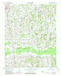
1956 Map of Mc Connell
USGS Topo · Published 1981About this map
The boundary between Obion and Weakley counties runs through this landscape of creek bottoms and agricultural uplands, centered on the North Fork Obion River. Settlement patterns follow the high ground and the corridor of the Illinois Central Gulf railroad, which links the community of McConnell with the southern edge of South Fulton. The map reveals a dense network of local landmarks essential for genealogical research, including the Chestnut Glade School and numerous country churches like Sandy Branch Ch and New Hope Ch. Smaller family burial grounds such as Thomas Cem and Scott Cem are scattered throughout the rural acreage, particularly near the winding courses of Richland Creek and Walnut Creek. Cultural markers of the mid-20th century are also visible, notably the Drive-in Theater located west of the central rail line.
Find a feature on this map
31 named features on this map. Tap any name to fly to it.
Don’t see what you’re looking for? This feature index may not catch every label — zoom into the map to look around manually.
Map Details
Editions of this 1956 Mc Connell Map
3 editions found
Other maps of this area

1950 · Martin
USGS Topo · 1:24,000

1952 · Crutchfield
USGS Topo · 1:24,000

1952 · Dresden
USGS Topo · 1:24,000

1952 · Cuba
USGS Topo · 1:24,000

1952 · Water Valley
USGS Topo · 1:24,000

1952 · Mayfield
USGS Topo · 1:62,500

1952 · Water Valley
USGS Topo · 1:62,500

1956 · Gardner
USGS Topo · 1:24,000

1956 · Harris
USGS Topo · 1:24,000

1956 · Mc Connell
USGS Topo · 1:24,000