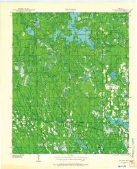
1939 Map of Mc Cord
USGS Topo · Published 1964About this map
The Willow Reservoir dominates the northern reaches of this landscape, fed by the winding Willow River and Tomahawk River. This 1939 field examination captures a transition in the Wisconsin Northwoods, where water management and reforestation efforts are evident through features like the Jack Pine Fire Tower and a CCC Camp. The southern portion of the map reveals a corridor of small settlements including Tripoli, McCord, and Clifford, many linked by the Sault Ste Marie No 8 rail line. Local education and community life are well-documented by numerous rural schools, such as Harmony Sch and Lund Sch, along with the Prairie Rapids Ch. The intricate network of County Trunk Highways and smaller roads suggests a logging and recreational economy emerging from the earlier timber era.
Find a feature on this map
46 named features on this map. Tap any name to fly to it.
Don’t see what you’re looking for? This feature index may not catch every label — zoom into the map to look around manually.
Map Details
Editions of this 1939 Mc Cord Map
3 editions found
Other maps of this area

1938 · Minocqua
USGS Topo · 1:48,000

1938 · Lac Du Flambeau
USGS Topo · 1:48,000

1939 · Lac Du Flambeau
USGS Topo · 1:48,000

1939 · Mc Cord
USGS Topo · 1:48,000

1939 · Cassian
USGS Topo · 1:48,000

1941 · Pike Lake
USGS Topo · 1:48,000

1941 · Brantwood
USGS Topo · 1:48,000

1942 · Pike Lake
USGS Topo · 1:48,000

1942 · Cassian
USGS Topo · 1:48,000

1943 · Brantwood
USGS Topo · 1:48,000