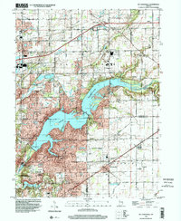
1998 Map of Mc Cordsville
USGS Topo · Published 2002About this map
Geist Reservoir dominates this central Indiana landscape, its intricate shoreline reaching into the corners of Hamilton, Marion, and Hancock counties. The late 1990s imagery reflects the residential expansion of communities like Fishers and McCordsville as they grew around the water. While modern subdivisions are evident, the map retains traces of the area's agricultural and rural roots, marked by family burial grounds such as Lowery Cem and Kinnamon Cem. To the south, the expansive Fort Benjamin Harrison State Park and Nature Preserve preserves a significant green space near Lawrence, while the Conrail line provides a persistent industrial link through the town of Oaklandon. The presence of landmarks like the Indianapolis Brookside Airpark and Indiana Gun Club highlights the varied suburban land use of the era.
Find a feature on this map
60 named features on this map. Tap any name to fly to it.
Don’t see what you’re looking for? This feature index may not catch every label — zoom into the map to look around manually.
Map Details
Editions of this 1998 Mc Cordsville Map
This is the sole edition of this map. No revisions or reprints were ever made.
Other maps of this area

1948 · Indianapolis East
USGS Topo · 1:24,000

1952 · Cumberland
USGS Topo · 1:24,000

1952 · Greenfield
USGS Topo · 1:24,000

1952 · Fishers
USGS Topo · 1:24,000

1952 · Ingalls
USGS Topo · 1:24,000

1952 · Mc Cordsville
USGS Topo · 1:24,000

1953 · Lapel
USGS Topo · 1:24,000

1953 · Riverwood
USGS Topo · 1:24,000

1953 · Noblesville
USGS Topo · 1:24,000

1953 · Cincinnati
USGS Topo · 1:250,000