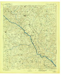
1892 Map of Mc Cormick
USGS Topo · Published 1944About this map
The Savannah River serves as the central artery for this region of Georgia and South Carolina, dictating the development of the borderlands long before modern bridges. At the end of the nineteenth century, the river economy relied heavily on a series of crossings like Barksdale Ferry, Mc Cord Ferry, and Fury Ferry, which connected rural communities across the water. Inland, the arrival of the Savannah Valley Railroad and the Port Royal and Western Carolina Railroad through Mc. Cormick signaled a transition toward more industrial transport, though small-scale milling remained vital, as seen at Searle Mill and Cade Mill. The map documents numerous local landmarks of genealogical value, including Hogan Store, Dunn Chapel, and Sharon Church, providing a spatial record of the social and commercial hubs that anchored these agricultural counties.
Find a feature on this map
129 named features on this map. Tap any name to fly to it.
Don’t see what you’re looking for? This feature index may not catch every label — zoom into the map to look around manually.
Map Details
Editions of this 1892 Mc Cormick Map
5 editions found
Other maps of this area

1892 · Mc Cormick
USGS Topo · 1:125,000

1892 · Abbeville
USGS Topo · 1:125,000

1893 · Elberton
USGS Topo · 1:125,000

1906 · Crawfordville
USGS Topo · 1:125,000

1908 · Kirksey
USGS Topo · 1:24,000

1912 · Mc Cormick
USGS Topo · 1:125,000

1920 · Clarks Hill
USGS Topo · 1:48,000

1921 · Augusta
USGS Topo · 1:62,500

1921 · Clarks Hill
USGS Topo · 1:62,500

1921 · Appling
USGS Topo · 1:62,500