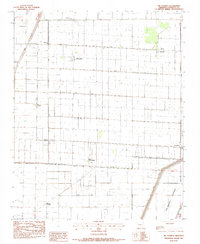
1983 Map of Mc Cormick
USGS Topo · Published 1984About this map
Agricultural precision and water management define this Poinsett County landscape, where a dense network of drainage channels such as Ditch No 11 and Ditch No 18 grid the terrain. The community of McCormick sits centrally, while the transition between Old Weona and the more modern Weona reflects the shifting settlement patterns of the Arkansas Delta. These small rural hubs are connected by section-line roads and specialized infrastructure like the Elevated Canal, designed to manage the flat, flood-prone geography of the region. Local heritage is preserved through landmarks like Promised Land Ch and Mt Zion Ch, which serve as anchors for the surrounding farmsteads. To the southeast, the massive Oak Donnick Floodway dominates the topography, marking the boundary of the intensive ditch system and the start of controlled overflow zones.
Find a feature on this map
27 named features on this map. Tap any name to fly to it.
Don’t see what you’re looking for? This feature index may not catch every label — zoom into the map to look around manually.
Map Details
Editions of this 1983 Mc Cormick Map
This is the sole edition of this map. No revisions or reprints were ever made.
Other maps of this area

1940 · Deckerville
USGS Topo · 1:62,500

1940 · Princedale
USGS Topo · 1:62,500

1940 · Dee
USGS Topo · 1:62,500

1941 · Marked Tree
USGS Topo · 1:62,500

1953 · Memphis
USGS Topo · 1:250,000

1956 · Marked Tree
USGS Topo · 1:62,500

1956 · Memphis
USGS Topo · 1:250,000

1956 · Princedale
USGS Topo · 1:62,500

1957 · Deckerville
USGS Topo · 1:62,500

1958 · Dee
USGS Topo · 1:62,500