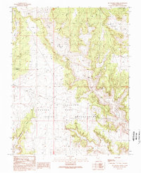
1989 Map of Mc Cracken Spring
USGS Topo · Published 1989About this map
The Navajo Indian Reservation encompasses the southern portion of this high-desert landscape in San Juan County, dominated by the expansive Navajo Mesa. This 1980s field-checked survey reveals a land defined by water scarcity and rugged relief, where named water sources like McCracken Spring, Alkali Well, and Alkali Seep represent critical landmarks for navigation and local ranching history. The terrain is deeply incised by drainage systems including McCracken Canyon and Alkali Canyon, while the northern reaches feature the broad Bullpen Swale. Human activity is primarily industrial and infrastructural rather than residential, marked by a Quarry and a network of pipelines and transmission lines crossing the arid plateaus. The presence of numerous drill holes across the mesas suggests an era of intensive subterranean exploration, likely for mineral or energy resources, set against the backdrop of traditional tribal lands.
Find a feature on this map
16 named features on this map. Tap any name to fly to it.
Don’t see what you’re looking for? This feature index may not catch every label — zoom into the map to look around manually.
Map Details
Editions of this 1989 Mc Cracken Spring Map
This is the sole edition of this map. No revisions or reprints were ever made.
Other maps of this area

1886 · Abajo
USGS Topo · 1:250,000

1892 · Abajo
USGS Topo · 1:250,000

1893 · Abajo
USGS Topo · 1:250,000

1955 · Verdure 3 SE
USGS Topo · 1:24,000

1955 · Verdure 4 SW
USGS Topo · 1:24,000

1956 · Cortez
USGS Topo · 1:250,000

1957 · Aneth 1 NW
USGS Topo · 1:24,000

1957 · Monument Canyon
USGS Topo · 1:62,500

1957 · Blanding
USGS Topo · 1:62,500

1958 · Cortez
USGS Topo · 1:250,000