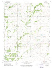
1973 Map of Mc Cune NE
USGS Topo · Published 1975About this map
The Neosho River and its meandering oxbows, including Little Halfmoon Lake and Halfmoon Lake, dominate the southern landscape of this mid-1970s survey. This corner of Southeast Kansas reveals a pattern of rural development shaped by township lines and natural drainage, where the Neosho State Waterfowl Management Area preserves the wetland environment near the Murphy Creek confluence. Genealogy researchers will find significant value in several clearly marked burial sites scattered across the townships, including Valley City Cem, Frog Cem, and Dumbald Cem. The presence of several Oil Fields and a Quarry in the eastern sectors indicates a local economy still tied to resource extraction. Throughout the quadrangle, the transition between Lincoln, Osage, and Grant townships is marked by section roads and country landmarks like the Green Elm Ch.
Find a feature on this map
20 named features on this map. Tap any name to fly to it.
Don’t see what you’re looking for? This feature index may not catch every label — zoom into the map to look around manually.
Map Details
Editions of this 1973 Mc Cune NE Map
2 editions found
Other maps of this area

1884 · Fort Scott
USGS Topo · 1:125,000

1886 · Joplin
USGS Topo · 1:125,000

1886 · Iola
USGS Topo · 1:125,000

1886 · Fort Scott
USGS Topo · 1:125,000

1886 · Parsons
USGS Topo · 1:125,000

1893 · Fort Scott
USGS Topo · 1:125,000

1893 · Iola
USGS Topo · 1:125,000

1893 · Parsons
USGS Topo · 1:125,000

1894 · Joplin
USGS Topo · 1:125,000

1904 · Iola
USGS Topo · 1:125,000